Today the Caddo Oil Field is in its twilight, and most current production comes largely from "stripper wells," that use a pumpjack (rocking horse mechanism) above ground to operate a subsurface pump in order to extract the oil, often at a rate of a few barrels per day.
However in the early days, the newly found oil and gas was under extreme pressure and once drilled came to the surface on its own, with numerous wells producing hundreds and even thousands of barrels per day. While drilling and through completion, measures to be taken to control and offset the pressure for, if not, the result could be a gusher (wasteful) or blowout (wasteful and dangerous). Occasionally through human error or unforeseen circumstance the latter would occur, with disastrous effects.
Located by the red arrows below are four significant area blowouts, the evidence of which can still be seen today. One is even a landmark many pass daily in their vehicles and may think of the legend associated with it.


Oil and Gas In Louisiana With A Brief Summary Of Their Occurrence In Adjacent States, Gilbert D. Harris, 1910, Government Printing Office, Pages 113, 114, and 116.
C. G. Dawes No. 1

C. G Dawes No. 1 shown burning at night.


Google Maps
Who was C. G. Dawes?
Charles Gates Dawes (1865-1951), the investor for whom the well was named, was an American capitalist who became a general in World War I and was elected Vice President of the United States on the ticket with Calvin Coolidge. He later served as ambassador to Great Britain. He was also a co-recipient of the Nobel Peace Prize for his work, titled the Dawes Plan, to resolve post World War I reparations issues.
 |
| Appearing on the cover of Times Magazine 14-Dec-1925 |
With his brothers Henry and Rufus, he invested in and established utility companies around the country including Southwestern Gas & Electric Company, which had a plant on the north shore of Caddo Lake that is now AEP/SWEPCO. Their name lives on in the area, attached to a small paved road near the plant that runs east-west on the north side of Caddo Lake.

Gilbert No. 1

Aerial map showing the well site south of Oil City.

The Gilbert No. 1 site today, looking west from La. State Hwy 1.

Legend
A long-held belief of many local residents is that the pool is bottomless. This has however been disproved on at least a couple of occasions. Former resident David Williams stated he once entered the pool in the 1970s using scuba gear and found it to be only about 25 feet at its deepest point, with the bottom relatively clean save for the cab of a truck found. Johnny Smith, former employee of W. C. "Dub" Allen and Sons, also advised it to be as similar depth. He had been involved with installing the metal pole shown in the middle in the picture above.
What is interesting to note about the pit is that it maintains the same water level, even during drought conditions, which should mean it is fed somehow by an underground source.
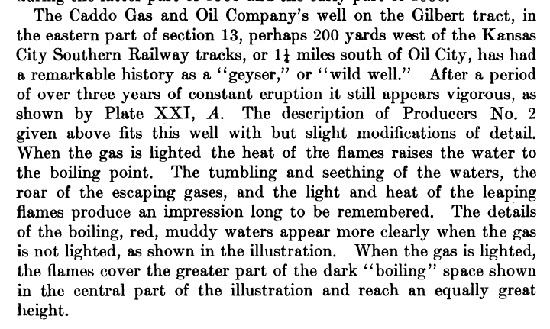
Producers No. 2


Louisiana Governor Newton C. Blanchard and Shreveport Mayor Andrew Querbes visit the burning well.

New Orleans Times Picayune 05-Nov-1905, Page 13
New Orleans Times Picayune 05-Nov-1905, Page 13
Fire from the burning well is reported to be visible over 25 miles away.


Aerial map of the sited of Producers No. 2 (left) and No. 3 (right) today.

Producers No. 2 site today, looking west from N. Ardis Avenue.

Google Maps
Producers No. 3

Oil & Gas In Louisiana, Page 136
Producers No. 3, looking south from N. Ardis Avenue. Note the First Baptist Church steeple in the background.

Google Maps
My great-grandparents, F.B. and Mattie Morrison, raised 7 kids in Oil City, very near to the one close to where First Baptist Church sits. Their house has been gone for years. One of my great-uncles used to tell me about the bottomless lake behind their house and I was always terrified of it!
ReplyDelete